Local Logic and Elm Street Bring Neighborhood Insights to IDX Broker Agent Websites
Partnerships
| 06 Oct 2026
TL;DR
There is no single correct definition of a neighborhood, so we carry as many as our customers need. As of the August 26, 2026 release:
Ask two people where a neighborhood ends, and you often get two different answers. Ask an appraiser, an MLS, a developer, and the person who has lived on the street for thirty years, and you get four.
That disagreement is not a flaw in the question. It is the question. It is also why, as of August 26, 2026, Local Logic supports 486,187 named geographies across the United States and Canada. Neighborhood boundary data at that resolution is not an attempt to draw one correct map. It is an attempt to carry enough definitions that whoever is asking can find the one matching their geographic reality.
Neighborhood boundaries are contested nearly everywhere, and the disagreement is measurable rather than theoretical. When the Bostonography project asked residents to draw their own neighborhood outlines, it collected around 300 submissions covering 21 Boston neighborhoods. Some came back clean: the North End was among the best-defined areas in the city. In Hyde Park, no part of the map reached even 75% agreement among the people who live there.
Two years ago we published a piece on who decides what a neighborhood is. The short version: appraisers define one thing, developers define another, MLSs largely decline to enforce a definition because there is no legal one to enforce, and residents hold the version that actually governs how people talk. All of those definitions are real, for different purposes.
That leaves a data company with a choice. Pick one definition and defend it, or carry as many as customers actually need. We picked the second, which means the work is unfinished by design.
The August release added named residential subdivisions as neighborhood-level geographies across every US state, following a first batch in Florida, California, and South Carolina in July. US neighborhood coverage moved to 364,462.
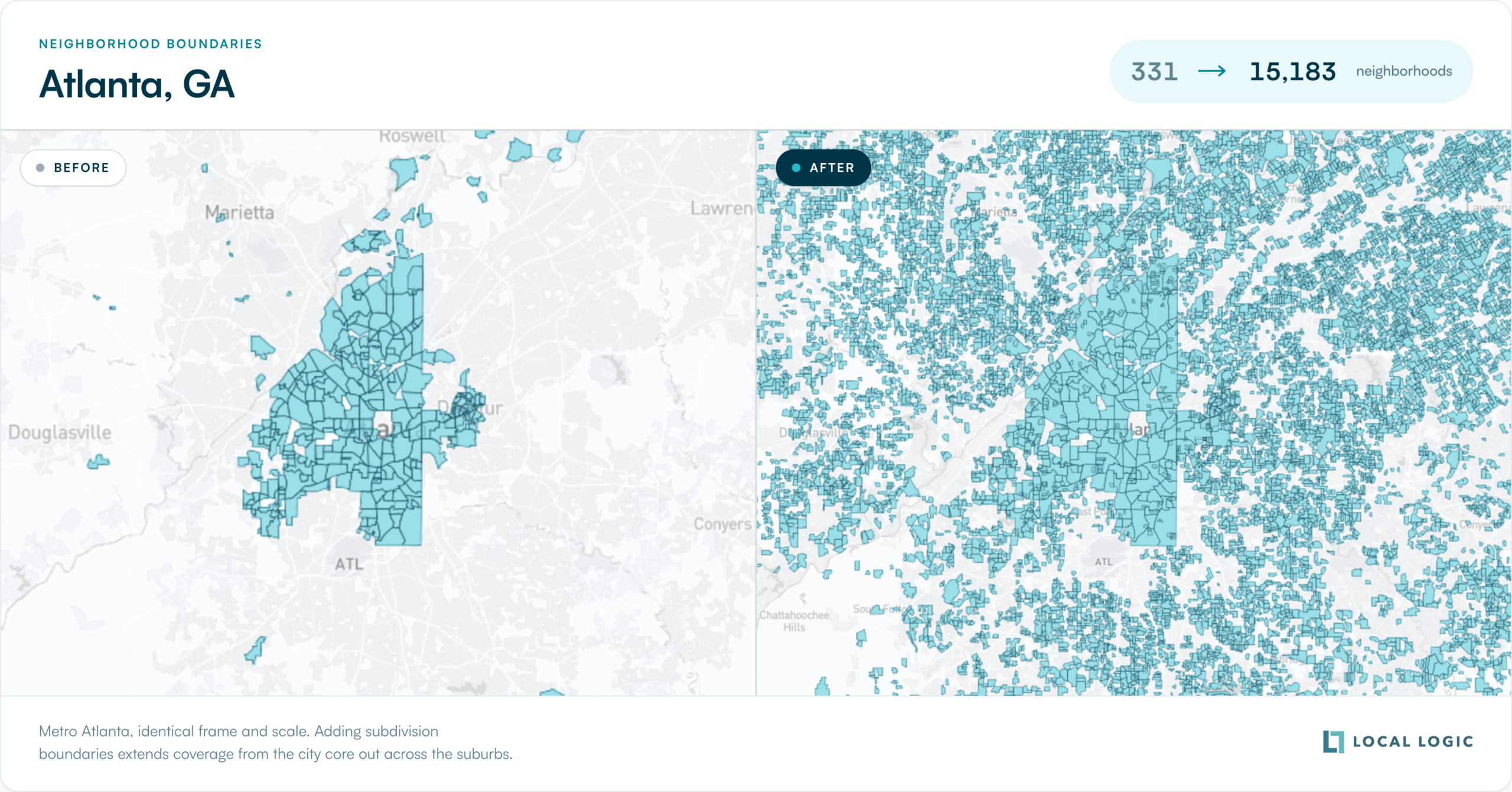
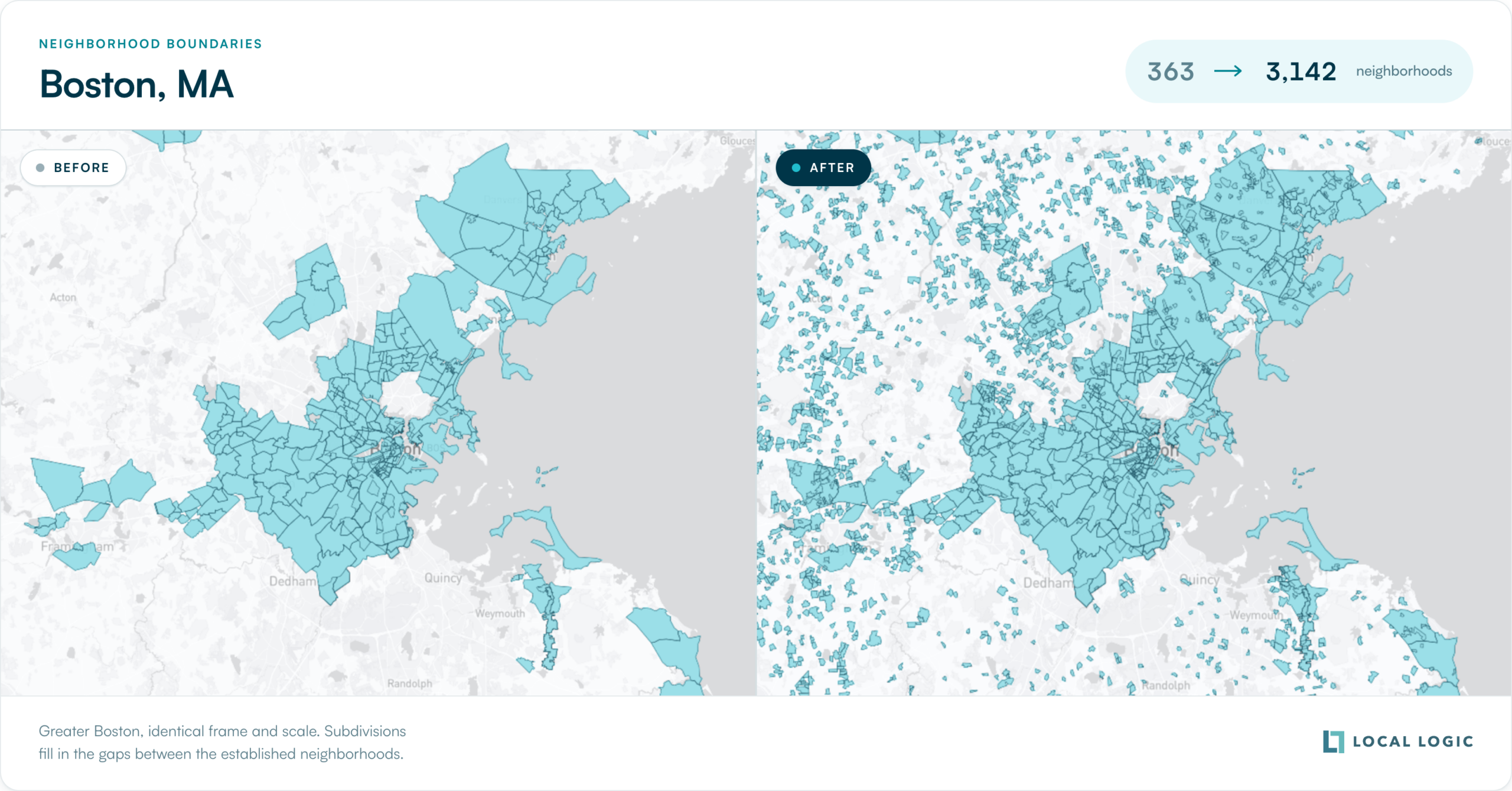
Metro Atlanta went from 331 neighborhoods to 15,183, and Greater Boston from 363 to 3,142. The two maps below are drawn at identical frame and scale, so the change is coverage rather than zoom.
Franklin, Tennessee is a good place to see what that means in practice. Query Franklin today and Local Logic returns 161 active neighborhoods: Fieldstone Farms, McKay’s Mill, Ladd Park, Berry Farms, Cool Springs East, Stream Valley, Tywater Crossing, and 154 more. These are the names posted at the entrance to each development. They are what people say when someone asks where they live, and what agents type into a search box.
Coverage here means data, not just an outline. Hardison Hills, one of those Franklin neighborhoods, returns a full profile: mainly single detached homes alongside townhouses and small apartment buildings, most built after 2000, a grocery store within a short walk, primary schools nearby, no high school inside the boundary, several bus lines and stops, limited bike lanes. That is measured detail about one named area of roughly a square kilometre, at the depth available for a downtown Toronto neighborhood.
A single coordinate sits inside several neighborhoods at once, and which one is correct depends on who is asking. Local Logic returns all of them, ordered from smallest to largest, and lets the caller choose. One coordinate in Franklin returns five nested geographies:
| Level | Name | Type |
|---|---|---|
| 10 | Hardison Hills | neighborhood |
| 30 | Franklin | city |
| 32 | Zip Code 37064 | postal code |
| 35 | District 11 | district |
| 37 | Williamson County | county |
An MLS building a member search experience may want level 10, because subdivision is the field its members already file listings against. A portal building community pages for organic search may want level 10 and level 32, because those are the terms people type. A mortgage team may want the county. None of those is wrong, and none of them has to accept someone else’s answer.
This is also why a name is not an identifier. Search Local Logic for Westhaven, and you get 38 different neighborhoods across 17 states, from Franklin, Tennessee to Bethesda, Maryland to Pearland, Texas. Any platform matching a listing to a neighborhood on the name string alone will get it wrong somewhere. Geography IDs exist for that reason, and every new geography has one.
For portals, the useful number is not 486,187. It is how many pages you can now build that somebody is actually searching for. A metro that supported a few hundred neighborhood URLs now supports thousands, each with its own neighborhood profile and scores rather than thin duplicated text.
For brokerages, agents compete on knowing the specific area, and that is usually the subdivision rather than a city quadrant. Profiles now exist at the level of the name a client says out loud.
For MLSs, subdivision is already a field in most systems. Coverage at that level means member-facing tools can align with the geography members already use, instead of translating between two vocabularies.
For platform and data teams, this arrived without a migration. Same endpoints, same ID format, more geographies behind them. If you take bulk data delivery, the new geographies appear in your next extract.
The list grows for two reasons that depend on each other. Customers tell us what is missing, and the pipeline can absorb what they ask for without a project plan wrapped around every addition.
In this release, tripling the geography count meant tripling the volume of market statistics produced, and the unit cost of producing them went down rather than up. A pipeline that can only be extended by spending more stops being extended.
A few weeks ago, we published the amenity score refresh that travelled from a raw POI snapshot to live scores in 67 hours. Same instinct, different axis: that release was about how fast the data moves, this one about how many places it moves for. Both come out of one decision, which is to put the engineering into ingestion and processing rather than presentation.
We also corrected and removed geographies in this release based on specific customer requests, and that continues. A list of 486,187 named places contains mistakes. Hearing about them is how the next version gets better.
The bigger picture
A neighborhood is not a shape on a map. It is the answer to a question someone is asking, and the question is usually some version of what my life would be like here. The person asking might be a home consumer, an agent, an underwriter, or a planner, and each draws the line somewhere else for a reason that holds up.
We are not going to settle that argument, and we should not try to. What we can do is keep the list long enough that nobody has to accept an answer that does not fit their reality. 486,187 is where that stands today, and it will be out of date next month in the direction of being larger.
See what your own markets look like at this level of coverage: book a demo.
As of August 26, 2026, Local Logic supports 486,187 named geographies across the United States and Canada. Of those, 364,462 are US neighborhood-level geographies and 11,993 are Canadian. The remainder are larger areas: cities, ZIP codes, county subdivisions, counties, and regions.
Level 10 is the neighborhood tier. Levels ascend with size: 20 for a borough or macro-neighborhood, 30 for a city, 32 for a ZIP code, 37 for a county, up to 70 for a country. Passing a level 10 geography ID to the Scores, Profiles, or POIs API returns data for that specific neighborhood.
Yes. The August 2026 release added named residential subdivisions as level 10 geographies across all US states, which accounts for most of the growth to 364,462. A subdivision now behaves like any other neighborhood: it has a geography ID, a boundary, a profile, scores, and points of interest.
No. They are available on the same endpoints with the same ID format. Coverage is live in the Location Scores, Profiles, Geographies, POIs, Schools, Value Drivers, Similar Neighborhoods, and Market Stats APIs, and in Neighborhood Reports and NeighborhoodWrap.
Because neighborhood names were never unique. A search for Westhaven returns 38 distinct neighborhoods across 17 states. Match on the geography ID rather than the name string, and use the city, state, and metro fields in the response to disambiguate when resolving a name from a listing.
Continuously, in batches: 150,725 in mid-June, 207,326 in late July, 486,187 in late August. Additions come from new boundary data and from customer requests for specific areas.